The History of Chester Square
In the beginning of the 19th century, Boston had a serious interest in developing what would become the South End to provide housing for the prosperous residents of the city who could no longer find homes on crowded Beacon Hill. By creating a handsome, spacious new neighborhood ranged around many landscape parks in the English style, the city hoped to prevent these merchants and professionals from leaving the city for the suburbs.1
Chester Square was designed in 1850 as one of the earliest American urban planning schemes, following designs made by Charles Bulfinch. These plans for dignified residential squares copied 19th century English prototypes. Unlike Blackstone and Franklin parks, the two parks in the South End with similar scale, Chester Square still retains its entire 19th century architectural framework and its entirely residential character.
Although city engineers designed a score of large and small park-centered squares in the South End, Chester Park “was considered the grandest square, not only because of its large size, but also because the City created a tree-lined… 20ft. wide mall extending along the center of the very wide street…” abutting the park.2
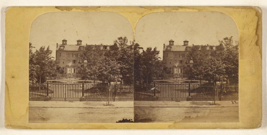 Chester Square, 1859 (Getty.edu)
On October 30, 1859, the city auctioned off the newly developed lots in Chester Square. Given a huge central fountain, the park was landscaped lavishly by the city while developers and property owners began building the seventy townhouses that surround the park. The handsome houses are a combination of flat fronted central buildings and stepped forward, bow fronted buildings at the curved ends and “are more grant and opulent in style and influence” than any other South End houses.3
By the end of the century, however, construction of the even grander Back Bay along French-style boulevards led to an exodus of the well-to-do from the South End’s squares. Within a few decades, the handsome houses of the South End became successively homes for small artisans, rooming houses and the residential entry point for waves of immigrants. Many fell into disrepair and were boarded up and abandoned. In the 1950’s, in the worst excesses of urban renewal, whole square blocks of the South End and Lower Roxbury were torn down as slums. Although none of the buildings that constitute the architectural framework of Chester Square were razed, in 1952 when the Southeast Expressway was completed, funneling thousands of cars into Boston from the South every day, the city took the center of Chester Park for four lanes of traffic. On its 100th birthday, the center of the historic residential square became a flowing river of traffic.
Starting in the 1960’s, the handsome, generous spaces within South End row buildings were rediscovered by investors, developers and young people searching for convenient inexpensive housing. The major public investments helped generate a wave of reconstruction and renovation that has not stopped yet. The wave moved through the South End, returning many abandoned historic buildings to residential and retail commercial uses and is now beginning to be visible in Lower Roxbury as high prices in the South End encourage people to look at the Victorian buildings in that neighborhood. At the same time, aggressive development efforts which partner public and private initiatives have transformed many of the empty spaces on Washington Street and Dudley Square in Roxbury into vibrant commercial and residential enclaves.
Chester Square Today
Chester Square and the South End can be seen as a paradigm for the 21st century city. This is a racially, socially and economically diverse urban enclave that has transformed its historic architectural fabric to serve its population into the new millennium.
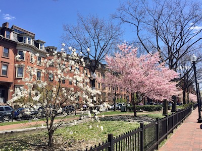
The dense mix of young new residents, old timers and empty-nesters returning to the city reflects Boston’s cultural, medical and educational attractions. The area’s history as an upper-class residential neighborhood and as the home of successive waves of immigrants enriches its present exciting mix of high end and ethnic restaurants, specialty stores, theaters, art galleries and concerts. In the shorthand of urban history, Chester Square stands as a lively symbol of success within the South End, affirming that it is possible to bring decayed urban neighborhoods back to vibrant life without tearing them down first.
Snapshot of the South End and Lower Roxbury
Boston’s overall population of about 600,000 has been relatively stable over the last decade, but its makeup has changed dramatically. Bostonians are highly mobile: half of the population moved out between 1980 and 1990 and half of the present population moved in during that time span. In the years between 1985 and 1990, one of every four arrivals in Boston was coming from abroad.3 Consequently, the ethnic, racial and linguistic diversity of the city as a whole has increased significantly and this diversity is one of the hallmarks of the South End/Lower Roxbury community.
The South End and Lower Roxbury are physically separated from the rest of the city by the Southeast Expressway, the Massachusetts Turnpike, Melnea Cass Boulevard and the Southwest Corridor. Between 1965 and 1979 over $135 million in public resources were invested under the urban renewal program in the South End in the construction of new streets, a new library, elementary schools, parks and new and rehabilitated housing. In the 1980’s major transportation improvements, including relocating the Orange Line, were completed. Putting the Orange Line into the Southwest Corridor depression allowed creation of a handsome ribbon park that reconnects the South End and the Back Bay.4
There has traditionally been a strong arts community in the South End and new development has expanded this sector of the community. Over a hundred artists’ lofts were built on Washington Street, sparking the renaissance of that street while a half-dozen galleries have opened their doors on Harrison Avenue, including the only gallery of antique and contemporary African art in the city. Both the South End and Lower Roxbury are noted for their restaurants and it is possible to dine on anything from catfish and collard greens to Panang curried duck and pad thai within blocks of Chester Square.
The square, as part of the South End, was listed in the National Register of Historic Places in 1973 and created a Landmark District of the City of Boston in 1983. Adjacent sections of Lower Roxbury, in the Douglas Square area, were also created a Landmark District in 1998.
1) “The Residential Square Transplanted – London to Boston”, Phebe S. Goodman, 1994
2) Strategic Planning: Information for Teams, 1995. Boston Police Department
3) “National Registry of Historic Places”, April 1973
4) South End/Lower Roxbury Development Policy Plan, May 1993. Boston Redevelopment Authority
History of Chester Square
